Downtown Chandler’s compacted alluvial sands behave differently than the loose, silty deposits near the Gila River Indian Community boundary. That contrast is exactly why a blanket geotechnical assumption fails here. We dig exploratory test pits to expose the actual soil profile at your specific lot. Each pit gives us direct visual confirmation of stratification, moisture variation, and the presence of any buried debris. Before we recommend foundation type or slab design, we verify what the auger might have missed. Complementing the pit with a resistivity survey helps us map lateral variability across larger parcels without digging dozens of holes.
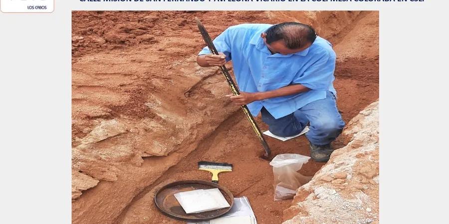
A single test pit can reveal a caliche layer at 3 feet that changes the bearing stratum from sand to rock-like carbonate.
Methodology and scope
Local considerations
We see it often: a builder relies solely on SPT blow counts and misses the weak, saturated silt layer at 5 feet that only a test pit would expose. In Chandler, caliche lenses can act as false bearing strata. A test pit from one corner may show dense gravel, while 50 feet away the same depth yields loose sand. That lateral variability is the real risk — not the average value. We always recommend at least two pits per residential lot and three per commercial pad to capture this heterogeneity before the foundation contract is signed.
Explanatory video
Applicable standards
ASTM D2488 (Visual-Manual Soil Classification), ASTM D420 (Standard Guide for Site Characterization), IBC Chapter 18 (Soils and Foundations)
Associated technical services
Pre-Construction Verification Pits
Excavation of 2–4 pits per lot before slab placement to confirm bearing strata and detect undocumented fill or buried utilities.
Utility Clearance Pits
Shallow pits (3–5 ft) to locate existing conduits or abandoned lines prior to deep excavation, reducing risk of service strikes.
Expansive Soil Assessment Pits
Targeted pits in areas mapped as high-plasticity clays (CH) near Chandler Heights Road to extract undisturbed block samples for swell-consolidation tests.
Caliche Layer Investigation Pits
Pits excavated to 6 ft specifically to identify and log cemented carbonate horizons that can affect spread footing design or require pre-trenching.
Typical parameters
Frequently asked questions
How deep do you typically dig exploratory test pits in Chandler?
We dig between 4 and 8 feet depending on the project scope. For single-family homes, 5 feet is usually enough to reach competent alluvial sand. For commercial pads or retaining walls, we often go to 8 feet to evaluate deeper strata.
What is the cost range for a standard test pit investigation in Chandler?
A typical residential investigation with two pits runs between US$490 and US$790, including mobilization, excavation, field logging, and a summary report. Larger commercial projects with four or more pits fall at the higher end of that range.
Do test pits replace SPT borings on a Chandler site?
No. Test pits give visual soil profiles and undisturbed samples, but SPT borings measure penetration resistance and recover disturbed samples at depth. We often recommend both: pits for shallow strata verification and SPT for deeper bearing layers.
Can you dig test pits near existing foundations or utilities?
Yes, but we coordinate with the contractor to mark all buried lines first. We stay at least 3 feet from existing footings and use hand tools within 2 feet of known utilities. Chandler requires Arizona 811 utility locate before any excavation.
What soil types are most common in Chandler test pits?
The most common are silty sands (SM), poorly graded sands (SP), and sandy gravels (GP). Near the southern edge of the city, you can find clayey sands (SC) and occasional caliche layers that require chemical testing for cementation.