For projects in Chandler, the 2024 International Building Code (IBC) and ASCE 7-22 require accurate subsurface characterization to avoid utility strikes and structural surprises. Ground penetrating radar provides a fast, non-destructive way to map buried pipes, rebar, and soil stratigraphy without excavation. In Chandler's alluvial deposits, where caliche layers can mask targets, combining GPR with a targeted estudio de SPT gives us the ground-truth we need to confirm anomalies detected in the radargram.
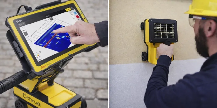
A single GPR line can reveal a buried 4-inch PVC pipe at 5-foot depth that no utility map shows, saving thousands in excavation costs.
Methodology and scope
Local considerations
Arizona's monsoon season brings sudden heavy rain that saturates Chandler's sandy loam, temporarily increasing electrical conductivity and reducing GPR penetration. We schedule surveys during dry periods or use shielded antennas to mitigate signal loss. The bigger risk is misinterpreting a caliche lens as a solid pipe: without ground-truthing via a clasificacion suelos laboratory test, you might plan a trench through what is actually a rock-hard carbonate layer.
Applicable standards
ASTM D6432-19 (Standard Guide for Using the Surface Ground Penetrating Radar Method), IBC 2024 Chapter 18 (Soils and Foundations), ASCE 38-02 (Standard Guideline for the Collection and Depiction of Existing Subsurface Utility Data)
Associated technical services
Utility Locate GPR Survey
Rapid grid-based scanning to mark all buried metallic and non-metallic utilities (PVC, concrete, fiber optic) within a project footprint. Includes real-time flagging and a digital map with depth annotations.
Structural & Void Detection GPR Survey
High-resolution imaging to locate rebar, post-tension cables, voids, and underground storage tanks. Ideal for slab-on-grade assessments, parking lot renovations, and foundation retrofits in Chandler's residential and commercial buildings.
Typical parameters
Frequently asked questions
How deep can GPR penetrate in typical Chandler soils?
In Chandler's dry sandy loam and gravel, a 200 MHz antenna reaches 12–15 feet. Clay layers or caliche reduce that to 6–8 feet. We choose the right frequency based on your target depth.
What is the cost range for a GPR survey in Chandler?
A standard utility locate survey for a 1-acre residential lot runs between US$820 and US$1,140, depending on grid density and site access. Larger commercial sites are quoted per acre after a brief site walk.
Can GPR detect plastic pipes and fiber optic lines?
Yes. GPR detects any material with a dielectric contrast. PVC and fiber optic cables show clearly in dry sand. Conductive clay or wet soil can mask them, which is why we sometimes recommend a complementary estudio de SPT for difficult ground conditions.
Do you need to mark the survey area before we arrive?
Yes. Please mark any known utility risers, valve boxes, or cleanouts with flags or spray paint. This helps us calibrate the radar and confirm that our detected targets match the as-built record.
How soon after the survey do we receive the report?
We deliver a PDF report with annotated radar profiles and a utility map within 48–72 hours. For emergency utility locates, we can provide a marked site plan on the same day.