Chandler sits on deep alluvial deposits from the Salt River, with sandy and silty soils extending well over 200 feet. The water table lies unusually deep here, often below 100 feet, reducing pore pressure concerns for most slopes. But the region’s flash-flood patterns can saturate near-surface layers quickly. That’s why slope stability analysis in Chandler must account for transient infiltration, not just static conditions. Before any cut or fill project, we run limit-equilibrium models using Mohr-Coulomb parameters from triaxial testing. For a complete subsurface picture we often pair this with seismic dilatometer testing to detect collapsible structures in the upper alluvium, and electrical resistivity surveys to map perched water zones after storms.
In Chandler’s deep alluvium, perched water from monsoon storms often triggers failures long before the water table rises — transient analysis is non-negotiable.
Methodology and scope
- Undisturbed sampling (Shelby tubes) for direct shear and triaxial tests per ASTM D3080 and D7181
- Groundwater monitoring with vibrating-wire piezometers during monsoon season
- Probabilistic analysis when variability in soil strength is high
Local considerations
We mobilize a track-mounted drill rig that reaches Chandler’s typical cut locations — often in new subdivisions near the San Tan Mountains. The operator advances a 4-inch hollow-stem auger to 50 feet or more, collecting undisturbed samples every 5 feet. A field engineer logs soil type, moisture, and blow counts on site. The samples are sealed, labeled, and transported to our ISO 17025-accredited lab within 24 hours. There, technicians perform direct shear and triaxial tests to define the shear envelope. The entire cycle — field to final report — takes 7 to 10 business days for a standard Chandler residential slope evaluation.
Applicable standards
ASCE 7-22 (Minimum Design Loads), IBC 2021 (Chapter 18 – Soils and Foundations), FHWA-NHI-05-039 (Slope Stability Reference Manual), ASTM D3080 (Direct Shear Test), ASTM D7181 (Consolidated Drained Triaxial)
Associated technical services
Limit-Equilibrium Modeling
Two-dimensional analysis using Spencer and Morgenstern-Price methods. We model circular, non-circular, and composite slip surfaces. Output includes factor of safety, critical slip location, and sensitivity to cohesion and friction angle.
Seismic Slope Stability
Pseudo-static analysis per ASCE 7-22 with horizontal seismic coefficient kh = 0.5 PGA. For liquefiable layers we run post-seismic stability using residual strengths from Youd-Idriss (2001). Suitable for Chandler sites near the San Andreas fault influence zone.
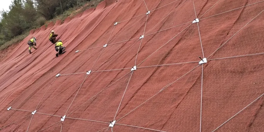
Reinforcement & Repair Design
Design of soil nails, geogrid-reinforced slopes, and retaining walls to bring marginal slopes to code-required safety factors. We include construction specifications, drainage plans, and QA testing recommendations.
Typical parameters
Frequently asked questions
How much does a slope stability analysis cost in Chandler?
A typical residential slope stability study in Chandler ranges from US$1,420 to US$4,330. The final cost depends on slope height, number of borings, laboratory tests, and whether seismic analysis is required. We provide a fixed-price quote after reviewing the site geometry and geotechnical reports.
What factor of safety does Chandler building code require for slopes?
IBC 2021 and the City of Chandler building code require a minimum factor of safety of 1.5 under static conditions for permanent slopes. For temporary cuts or seismic loading, the minimum drops to 1.1. These values apply to both natural hillsides and man-made fills.
How deep are soil samples taken for slope analysis in Chandler?
Borings typically reach 5 to 10 feet below the base of the critical slip surface, but never less than 20 feet total depth. In Chandler’s deep alluvium we often go 30 to 50 feet to capture the full soil profile, including any weak layers that could control failure.
What if my Chandler property has a landslide history?
We run a back-analysis of the failed slope to back-calculate actual shear strength at failure. Then we design remediation — typically soil nails or a tieback wall — to achieve a factor of safety of 1.5. The report includes instrumentation recommendations for long-term monitoring.