Working on a construction site in Chandler, we often see fill placed during the dry spring months when the native soils — mostly sandy loams with low plasticity — lose moisture fast. If compaction control isn't tight, you end up with a subgrade that passes a nuclear gauge but fails a sand cone. That's why we run the field density test (sand cone method) on every import and native soil lift. It gives us a direct measurement of wet density and water content, and from there we calculate dry density and percent compaction. We cross-check results against the project's Proctor curve, and when the material has oversized particles we combine it with a granulometry to see if the gradation is the culprit. In our experience, the sand cone catches segregation that nuclear gauges miss — especially in the variable alluvial fans this valley is known for.
The sand cone catches segregation that nuclear gauges miss — especially in the variable alluvial fans this valley is known for.
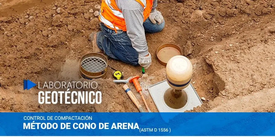
Methodology and scope
Local considerations
Chandler sits at an elevation of about 1,200 feet on the Salt River Valley floor, where groundwater levels have dropped significantly over the last 50 years. That means the unsaturated zone is thick, and soils can collapse if not compacted properly. After a monsoon event, differential settlement in poorly compacted fill can reach 2 to 3 inches in a single season. The field density test (sand cone method) is the only compaction control that works reliably in these dry, non-cohesive sands. We've seen what happens when a developer skips it — cracked slabs, tilted curbs, and costly repairs. In Chandler, the city requires compaction reports for every structural fill thicker than 12 inches. We provide those reports with sand cone data that holds up in review.
Explanatory video
Applicable standards
ASTM D1556-16 – Standard Test Method for Density and Unit Weight of Soil in Place by Sand-Cone Method, ASTM D6938 – In-Place Density and Water Content of Soil and Soil-Aggregate by Nuclear Methods, ASTM D698 – Standard Proctor (moisture-density relationship), IBC 2018 Section 1804 – Excavation, Grading, and Fill
Associated technical services
Standard Sand Cone Density Tests
Routine field density test (sand cone method) on structural fill, utility trench backfill, and subgrade. We provide same-day results and a signed report with percent compaction, moisture content, and Proctor reference.
Nuclear Gauge Correlation
For projects using a nuclear density gauge, we run a sand cone correlation at the start of each day and after any change in material. This ensures your gauge readings stay accurate in Chandler's variable alluvial soils.
Compaction Test Reporting
Complete documentation for city inspections and structural engineers. Reports include test location map, density data, Proctor curve overlay, and pass/fail analysis per project specifications.
Typical parameters
Frequently asked questions
How much does a field density test (sand cone method) cost in Chandler?
A single sand cone test typically ranges between US$100 and US$170 per point, depending on access, depth, and number of tests per visit. Volume discounts apply for projects with 10 or more test locations. We provide a flat-rate quote before mobilizing.
How does the sand cone method compare to a nuclear gauge in Chandler soils?
In Chandler's sandy and gravelly soils, the nuclear gauge can read high due to mineral density variations. The sand cone method gives a direct gravimetric measurement — it's the reference standard for compaction disputes. We recommend a sand cone for every 10 nuclear gauge readings to maintain correlation.
What depth should the test hole be for structural fill?
For lifts up to 8 inches thick, we dig a 4-to-6-inch deep hole. For deeper lifts — common in road subgrade — we extend the hole to 6 inches. The key is to test the full lift thickness, not just the surface crust. We always mark the test location so the inspector can verify.